Environmental database reports for Phase I ESAs
The records search for your Phase I, with its sections drafted in Word.
Federal and state environmental records at ASTM E1527-21 search distances, each cited to the agency that published it, in about five minutes. The records review, physical setting and data-gap section arrive drafted.
You add the site visit, the interviews, the user's information, the historical review, any file reviews, your conclusions and the signed declaration.
$49 a month for unlimited reports, or $149 for one, ordered online. Your first report is free with a work email, up to 2 miles.
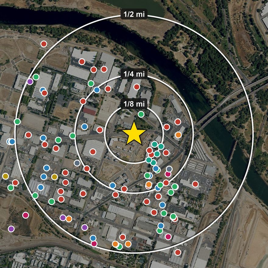 From the public sample, a one-mile search in Sacramento. See the whole report
→
- 32 federal databases for every property
- 342 state databases across all 50 states + DC
- About 5 minutes from address to report and draft
- Every record cited to its agency, with the source's date
What every report includes
One price, every format.
A Phase I draft in Word
The records review, the physical setting and the data-gap section, written out for you to edit.
Details
The site description, the records review written out as prose, the physical setting, the historical sources by year, the vapor screen and the data gaps, in the order of a Phase I report. Facts only: your findings, opinions and conclusions stay yours to write.
Records at ASTM E1527-21 distances
Federal and state lists, with adjoining properties banded.
Details
NPL, deleted NPL, RCRA (TSD, generators, corrective action), Superfund/SEMS, state cleanup registries where the state publishes one, LUST, UST/AST, spills, brownfields, VCP, institutional controls, dry cleaners, landfills and water wells, each at its E1527-21 distance, with adjoining properties banded. Tribal LUST and UST records are searched nationally. Tribal cleanup sites are searched on Alaska Native (ANCSA) lands, from EPA's inventory of contaminated sites there. Local records are collected only where a city publishes them as open data (Chicago, New York, Miami-Dade, San Francisco, Seattle); individual tribes' own registries are not searched. The coverage page names these limits and each state that publishes no list for a class.
Historical sources included
Topographic maps, aerial photographs, Sanborn maps and city directories, each linked.
Details
USGS topographic maps, aerial photographs counted by year, Sanborn fire-insurance volumes and city directories for the property, each linked to the public archive that holds it. Not a separate tier.
Gradient and vapor screen
A gradient for each record where the terrain shows one, and a Tier 1 vapor screen.
Details
Up-, down- or cross-gradient against the inferred groundwater flow, where the terrain shows a flow direction. Where it does not, the report says the gradient was not inferred, and why. The reasons are flat terrain (a fitted slope under 0.3%), irregular terrain and open water at the low point. Every report also has an ASTM E2600 Tier 1 vapor encroachment screen, in the tables and the exports.
A reliance letter and a field map
A letter naming your parties, and a map that opens with no signal.
Details
An addressable reliance letter naming the parties you list at order time, and an offline field map you save before the site visit and open with no signal.
Data you can work with
PDF for the file, Excel and GeoJSON of every finding, and a free refresh against current agency data for 180 days.
How it works
About five minutes from address to draft.
- Enter the addressConfirm the parcel on the map and pick a radius. Distances are measured from the parcel boundary where the county publishes one.
- Get the report by emailThe link comes to your work email when it is ready: the report, its data files and the Word draft.
- Finish the Phase IOpen the draft, add your site reconnaissance, interviews and conclusions. Highlighted brackets mark everything only you can supply.
Pricing
$49 a month for unlimited reports, with the first month free on a work email and no card. One report is $149, and your first one is free with a work email, for a radius up to 2 miles. Every report includes a Phase I draft in Word.
First month free
Monthly plan
- Unlimited reports for one person, up to 25 in any 24 hours
- Any radius up to 5 miles
- Start with a free month on your work email. No card needed to start
- Add a card only to keep it. Cancel any time on your account page
Per matter
Single report
- The same report, bought once for one matter. No account and no plan.
- Your first report is free with a work email, for a radius up to 2 miles
- Pay by card at checkout
Billing a matter, and which emails are free
- One matter is a legal case, a loan file or a property sale
- The delivery email is your receipt. It names the property and the order number, so the charge can be billed to the matter
- A work email is an address at your own firm's domain. We email the report's link to it when it is ready.
- Personal addresses such as Gmail, Yahoo, Outlook.com or iCloud can still order at $149
Records updates, litigation packages and other services
Inside the first 180 days a refresh is free; after that, a records update is $99. Need the high-resolution aerial scans themselves rather than the linked frames? USGS queues each one, so we pull them on request — orders@groundfax.com. Buying for a portfolio? Write us. Litigation data work beyond scope bills at $135/hr; expert services (opinions, expert reports, testimony) are engaged separately and are not part of any Groundfax product.
Groundfax reports are compilations of public records — they do not contain an environmental professional's opinion.
Your state's data-gap section, drafted
Every report says which record classes your state answers from its own registries, which a named federal source covers, and which no source exists for.
How the coverage notes work
40 CFR 312.26 names the record classes a Phase I has to check, and not every state publishes a source for every class. Every report ships jurisdiction coverage notes for its state: which classes the state answers from its own registries, which resolve from a named federal source, and which no source exists for at all. Only the last is an open gap, and where none is open the report says so, a sentence you can cite. What any of it means for your assessment stays your determination.
Compare us on ground you already know
Or read the sample report first: a real, unredacted one-mile search beside the Sacramento railyards, dense on purpose. You can also download its Word draft.
If anything looks wrong or missing, write hello@groundfax.com. A person reads every message, and it is how we find what to fix.
Questions
What is in the Word draft?
The sections public records can answer, in Phase I order: site description, records review in prose with a table by database, physical setting, the historical sources found for the property with a year-by-year table to fill in, the vapor encroachment screen, the listings an assessment usually examines first, and the data gaps. Everything only the site visit, the interviews or your judgment can supply is a highlighted placeholder.
What happens when the free month ends?
If you have not added a card, it simply ends and nothing is charged. If you have, the plan renews at $49 a month until you cancel on your account page. We email you three days before the month ends.
Can my colleagues use my plan?
A plan is for one person. Each colleague can start a free month with their own work email.
Will I need anything besides this report and a site visit?
Yes. A Phase I also needs interviews, the user's information, a lien search, a review of the historical sources and your signed declaration. What a Phase I needs beyond the records search lists each part and who supplies it.
Is this an environmental database report?
Yes. Records search, environmental database report and radius report are names for the same kind of report. What an environmental database report is lists what one contains.
Is this a Phase I?
No. It is the records search a Phase I relies on, with drafted sections to edit. The findings, opinions and conclusions are the environmental professional's.
Who is behind Groundfax?
Groundfax is a product of IQIS LLC, a California limited liability company. The terms, the privacy policy and the coverage of every state are published.
Check our work
Coverage disclosure
Every database we search in your state, at its ASTM distance, plus the record classes no agency publishes at all, stated plainly.
Retrievable at its original link
We intend to keep every issued report retrievable at its original link for at least seven years, as the terms say. The SHA-256 of every artifact is recorded at issue, so a report cited in a Phase I can be shown to be unchanged.